 The study focuses on transport accessibility in different areas of Moscow, from which areas to travel faster to and from the centre of the city, and from which to the private car. The study uses data from the Yandex services.Maps and Yandex♪ Samplings for September-November 2011.
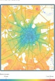
Transport accessibility of different areas of Moscow was assessed through the Yandex.Cart routing technology. It allows a route to be built on a city to travel on a motor vehicle or public transport and to set time on the road load.
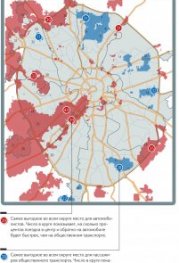
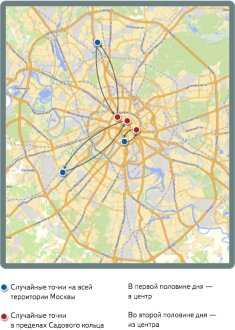
A set of random routes was used for the study. Each route connects two randomly chosen points, one anywhere in the city, the other in the Side ring. For each route, it compared time on the road and on public transport. Of a few options for public transport, the fastest choice was made. In the morning hours (from 8 to 10 a.m.), the routes were routed to the centre, in the evening (from 6 to 8) from the centre. Every hour, new 3,500 random routes were selected. In just two months, the travel time for approximately 600,000 routes, half of them for the morning peak hour, half for the evening.
1
During the data collection (Autumn 2011), more than a dozen public transport lanes were opened in Moscow. Mostly on major radial lines. The introduction of public transport lanes has just started, many of them have been unstable and not fully operational, including for vehicle traffic and parking.
The study therefore did not take into account the identified lanes in estimating the time spent on ground transportation. It is worth remembering, however, that in some parts of the city, the time of land transport, calculated by the Yandex service. Maps, maybe a little more real.
It is not possible to draw conclusions on the impact of the allocated lanes on Moscow ' s overall situation on the roads. However, these data may be useful in comparing the road situation in Moscow at the beginning of the introduction of the lanes and at the time it is completed.
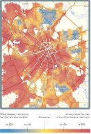
8-10 a.m., center
The blue map is marked by areas where public transport moves faster than a car. Red is the opposite. ♪ ♪